ICELAND / POI 17

Weather in Iceland
Where sun, wind, rain, and fire collide
The climate of Iceland is subarctic near the southern coastal area and tundra inland in the highlands. The island lies in the path of the North Atlantic Current, which makes its climate more temperate than would be expected for its latitude just south of the Arctic Circle. This effect is aided by the Irminger Current, which also helps to moderate the island's temperature. The weather in Iceland is notoriously variable.
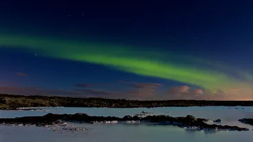
The aurora borealis is often visible at night during the winter. The midnight sun can be experienced in summer on the island of Grímsey off the north coast; the remainder of the country, since it lies just south of the polar circle, experiences a twilight period during which the sun sets briefly, but still has around two weeks of continuous daylight during the summer.
Winter
The Icelandic winter is relatively mild for its latitude, owing to maritime influence and proximity to the warm currents of the North Atlantic Gyre. The southerly lowlands of the island average around 0 00b0C (32 00b0F) in winter, while the Highlands of Iceland tend to average around 221210 00b0C (14 00b0F). The lowest temperatures in the northern part of the island range from around 221225 to 221230 00b0C (221213 to 221222 00b0F). The lowest temperature on record is 221239.7 00b0C (221239.5 00b0F).
Summer
The average July temperature in the southern part of the island is 10201313 00b0C (50201355 00b0F). Warm summer days can reach 20201325 00b0C (68201377 00b0F). The highest temperature recorded was 30.5 00b0C (86.9 00b0F) in the Eastern fjords in 1939. Annual average sunshine hours in Reykjavík are around 1300, which is similar to towns in Scotland and Ireland.
Winds and storms
Iceland, especially inland and during winter, is frequently subject to abrupt and dramatic changes in weather that can sharply reduce visibility, as well as rapidly increasing wind speed and precipitation, and shift temperature.
Generally, wind speeds tend to be higher in the highlands, but topographical features can aggravate winds and cause strong gusts in lowland areas. Wind speed in the lowlands reaches 18 m\/s (40 mph) on 10201320 days per year, but on upwards of 50 days per year in places in the highlands. The strongest measured 10-minute sustained wind speed is 62.5 m\/s (140 mph) and the strongest gust 74.2 m\/s (166 mph). Heavy dust storms can be generated by strong glacial winds, and can be very strong. Up to 10 t (9.8 long tons; 11.0 short tons) of material can be in motion per transect per hour. These storms are very frequent in the early summer in the arid highland areas north of the Vatnajökull glacier.
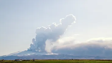
Thunderstorms are extremely rare for any specific location in Iceland, with fewer than five storms per year in the southern part of the island. They are most common in early or late summer. They can be caused by warm air masses coming up from Europe, or deep lows from the southwest in wintertime. Lightning can usually be observed in connection with ash plumes erupting from the island's volcanoes. Vortices, sometimes on the scale of tornadoes, also occur with volcanic eruptions. Landspouts and waterspouts are occasionally observed. Classic mesocyclone derived tornadoes (i.e. forming from supercells) are very rare, but have been observed. Any of these do occasionally cause damage, although the sparse population further reduces the probability of detection and the hazard.
(Wikipedia)

Get maps, navigation, favorites, and the full guide experience on your iPhone.
More in ICELAND


More Guides spots